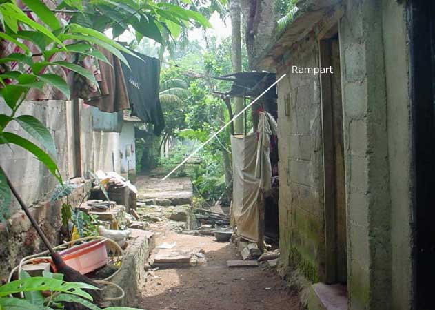
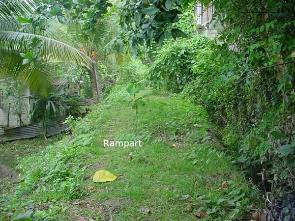
Thousands of people who travel daily down the parliament road and head for the city for their work, pass thru the picturesque suburbs of Atul Kotte. Little do they realize that this tranquil place bordering the Diyawanna Oya was once a walled citadel, the one time seat of power of the whole country, the throne of the last ever king who managed to rule a unified Lanka, and also home to the most sacred tooth relic. Little will they realize that within one hundred meters of this well traveled path lie the remains of the ramparts that protected the city.
The glorious past of Kotte is relatively unknown to many. Although not as magnificent as the other ruined cities of the country, the remains of Kotte also needs it’s due recognition. It needs to be restored to a state worthy of its past, and preserved for the benefit of the generations to follow. Sadly these remains lie today at the ends of unknown lanes, inside temple premises and on the homes and back yards of many people, unseen and forgotten.
Other than the invasions and internecine warfare, two reasons are attributed for the disappearance of the remains of Kotte. Extensive use of Kabok and the close proximity to the seaport and later day capital of Colombo accelerated its disappearance.. Unlike the great cities of Anuradhapura and Polonnaruwa, which were built mostly using granite, the architects of Kotte used the raw material found in abundance in the vicinity. From the ramparts to the magnificent three storied buildings that housed the Kings Palace, kabok and clay were the main raw material used in its construction. One of the places from which the kabok blocks were mined, could be seen even today inside the Ananda Sasthralaya premises. It is said that most of the kabok blocks that were in the ramparts, ended up as the foundations for the later day homes.
Its close proximity to Colombo also affected Kotte in many ways. After invading forces plundered the city, the Portuguese (who decided to abandon Kotte to defend their interest in Colombo), took back whatever useful remains to construct and fortify their fort and ramparts in Colombo. Kotte remained covered in jungle for many years, until the expanding population of the new capital encroached on the once royal lands, again destroying whatever remains that were in place. In these once royal lands, there arose the new brick and mortar suburban metropolis of Kotte. The capital, having already expanded to the north and the south then expanded to the marshy lands of its eastern borders.
With the decision to redevelop Kotte as the administrative capital in 1979, great development activities took place in the environs. Broad new roads and the reclamation of marshland accelerated the development of Kotte, bringing thousands of land hungry working class people to the area. The waterways of the Diyawanna Oya and the Kolonna Oya that skirted the old city, took on different shapes with major works that was undertaken to dredge and reclaim land to build the new parliamentary complex. Most of the marshy area that offered protection to the old city has now been filled up, and homes and offices built on the reclaimed land. With the shifting of the administrative capital, Kotte got back its former name of Sri Jayawardhanapura Kotte, but little of its former glory.
Kotte was the capital of our island from 1415-1565 AD. It is estimated that the moat and the rampart of the city was built still earlier, around 1360 – 1392. More details of the rise and fall of this great Kingdom could be found in the preceding articles. This and the following pages hope to take the reader on a quick tour of the meager remains that could be found of this once great Kingdom. Unlike the large number of books that you will find for the better-known historical sites of Ceylon, no decent guidebook exists for Kotte. The only guidebook dedicated to Kotte (in Singhalese) is prepared by the Ministry of Cultural Affairs, as part of its Singhalese Encyclopedia extracts (ISSN – 1391 – 1538). This could be bought from the Ministry of Cultural Affairs at Sethsiripaya or at its branch bookshop, the Jayanthi Book shop adjoining the National Art Gallery in Colombo. The main centerpiece for archeological information seems to be the Kotte Archeological Museum, sited at the former home of E. W. Perera. True to Sri Lankan style you will not find the guidebook for Kotte at this museum.
Like most similar cities of that era, Jayawardhanapura was built with security in mind. A natural swamp and two rivulets offered protection from three sides. A rampart built by Nissanka Alagakkonara a minister, protected the entire city. Traces of this moat and rampart are now visible at certain places. The Dalada Perahara is said to have paraded along sections of the rampart, complete with elephants. Along parts of the rampart, encroachers have now built houses, garages and even toilets, as you will find in the virtual tour in the next few pages. Road names in Kotte reveal many edifices of its rich past. The Palace road name board is all that you may see of anything close to a ‘Palace’. At least the Rampart Road leads you to a few remaining portions of the ramparts. Angampitiya Road leads to a place probably used as the sports venue of the capital. Angam Pora were games of war practiced by the warriors. The Alakeshwera road leads to the graves of this great minister, and also to the probable location of his palace. The ‘Ihala Wallauwa’ of the great freedom fighter E. W. Perera has been donated to form the Kotte Archaeological Museum. It is at the top this same hill that the ‘Vibhushana Devale’ (or the Kataragama Devalaya) has stood in the former years.
The Diyawanna Oya, Kolonna Oya and marshy land covered the walled city from three sides, offering natural protection from enemy attacks. The path of the Diyawanna and Kolonna Oya has changed considerably with the development activities, and do not resemble the extent covered in the early days. The two maps displayed in this page will give you an idea of these changes. The south of the city was protected by an inner moat called the ‘Atul Diya-agala’. Remains of this could be seen to this day. The walled city ended at a point south of the Museum premises. The outer limits of the city however ended near the present day Pita Kotte junction. A moat, known as the ‘Pita Diya-agala’, offered protection to the inhabitants. Remains of this could be seen near ‘Srikotha’ the headquarters of the United National Party. Part of it has been bulldozed and filled up and used as a car park.
Beyond the city, one could find the remains of the Stupas at the Weherakanda Road. The ‘Gal Ambalama’ or a resting place for the weary traveler could be found right in the middle of the Pita Kotte junction, its sister edifice the ‘Mati Ambalama’ being destroyed. Little beyond, within the premises of the Ananda Sasthralaya school, one could find the remains of a place of worship or a tunnel entrance, carved out from the kabok mines.
The northern entrance to the city has been at a place close to the present day Atul Kotte turnoff. Interestingly, the present day Kotte road that connects Atul Kotte and Pita Kotte, roughly traces the main thoroughfare of the olden day Kotte.
Having gone thru and visited these remains, a visitor is taken over by a sense of sadness at the loss of this once magnificent city. Built to protect the inhabitants from the northern invaders, and having withheld many a siege, the walled city has been ravaged and destroyed by our own people, the Portuguese and other colonial powers, then again by our own who have buried the city under a fresh pile of concrete. Its neigh impossible to imagine the pillage and destruction or the neglect of the present day Dalada Maligawa. But that’s what exactly happened at Kotte. The remains of the Royal Palace probably lay buried under someone’s house or the garden. The Dalada Maligawa was destroyed and converted to a church by the Portuguese. Nothing remains of these today.
The protection of these last remains are today entrusted to the archaeology department. The under resourced department is engaged in a lone battle to save the remaining pieces of old Kotte. Against all odds they try to keep the remaining portions from being destroyed or built upon at times by powerful politically backed parties. Building codes are either not in place or virtually impossible to enforce. The place reminds one of the ‘leftovers’ on a plate of food, each scavenger having gobbled up piece-by-piece and leaving over the ‘worthless’ pieces for the next scavenger to come along.
Destroyed beyond belief, it is now almost an empty plate, licked clean. It will not be long before most of these remains go under a bulldozer or a mountain of concrete, never to see light again.
Fonny de Fonseka
© J. F. R. de Fonseka, 2002.
UPDATE 2018 / 2019:
Much has changed for the better since this article was written. By mid 2018 work has started on the conservation and restoration of the ramparts along the Nippon Road and the Inner City Moat areas. The condition of the rampart and both the inner and outer moats are very much better than as depicted in these images. The Alakeshwara tomb area is fenced and protected. Almost all the sites carry display boards explaining the significance of the place to visitors. In multiple visits during 2018/19, the author always noticed well manicured lawns, and continually maintained premises in all the sites. Kudos and appreciation to the staff of the Archaeology Department and everybody involved in the conservation.


